If you don’t know where you are, you don’t know who you are.
Wendell Berry
While driving to the headwaters of the Middle Fork and Main Salmon rivers in Idaho, my husband Michael and I talked about different ways to think about watersheds and how watersheds connect us to rivers and streams. Is your watershed defined by physical proximity, limited to the water flowing near where you reside? What about the — often different — watersheds that provide the water you drink or the electricity that powers your home?

A trail leading into Puget Park ravine.
My immediate, physical watershed could be defined as the Puget Creek watershed. Puget Creek runs just blocks from my house through a cool, shady ravine, capturing runoff and discharging from my neighborhood’s slice of north Tacoma. It emerges from both pipes and natural springs, flowing about half a mile only to be buried as it crosses under Ruston Way where it gushes into Puget Sound out of a large culvert wedged in piles of rip rap armoring the shoreline.

Puget Creek begins its short run to Puget Sound’s Commencement Bay.
Puget Creek flows into Commencement Bay, once known as Puyallup Bay. Today as I look out at the bay, it is a singular silvery gray reflecting the layers of clouds overhead. But on some days, its colors divide along a striking sharp edge from ultramarine blue to a shimmery muted rose, neutralized ochre, or even lavender. The color of the bay changes dramatically when glacial silt, or till, filters into it from its source on the glaciers of Takhoma or Tahoma, Washington’s tallest mountain. The glacial till coloring Commencement Bay emanates from the Puyallup, Carbon, Fryingpan, and Emmons glaciers. Melting snow and ice pull the mountain’s sediment into the deep bay (itself carved by an ice age glacier), connecting the City of Tacoma with its namesake mountain. Tacoma or Takhoma is Lushootseed for “mother of waters.” The mountain and my city’s name tell a story about how water travels from a source to offer sustenance — the story of a watershed.

Glacial silt from the Puyallup River and its tributaries transforms Commencement Bay.
While there is beauty in the connection between the city of Tacoma and its majestic namesake there is also loss. The mountain was renamed Rainier after a friend of Peter Puget’s who never visited North America, and both it and the city named after it lost a connection to native and natural history and to each other. While Seattle business interests won repeated battles (so far, anyway) to keep The Mountain officially named after an otherwise anonymous member of the British Royal Navy, Seattle has lost its own historic riverine connection to The Mountain. The White River, which once flowed to — and colored — Seattle’s Elliott Bay after merging with other rivers to form the Duwamish, is now diverted into the Puyallup River and Commencement Bay. The Duwamish once carried some of The Mountain’s glacial till into Seattle’s Elliott Bay. And with that diversion, Seattle’s direct, physical connection to Takhoma is gone.
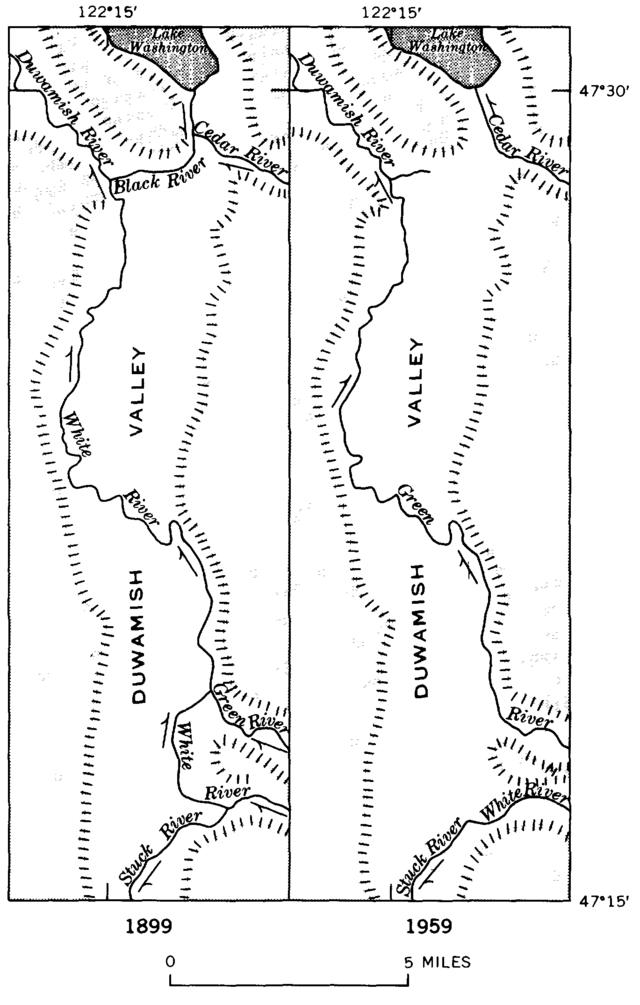
The Duwamish River watershed lost its connection to The Mountain when it the White River was diverted to the Puyallup RIver and Commencement Bay.
The White River is wild and braided, its uncontrollable meanderings were not appreciated by farmers who settled in the fertile valleys on either side of the Pierce and King County border, the floodplains between two rival cities. A giant log jam burst forth in 1906, diverting the White River from the Duwamish watershed into the tiny Stuck River, a tributary of the Puyallup. The White River’s would-be temporary shift from the Duwamish to the Puyallup was also a shift from King to Pierce County, and ultimately from Seattle to Tacoma. Neither county or city wanted the White and its contribution to flooding. There were lawsuits between the counties as Pierce fought to return it to its natural riverbed and King built embankments to prevent a reunion with the Duwamish. In 1913, the White’s detour became permanent when Pierce County agreed to keep it as long as King County paid for 60 percent of the flood control costs. A flood control dam, levees, and dredging ensured that the White would not return to its original watershed anytime soon.

The braided White River.
Photo Credit: Walter Siegmund, https://commons.wikimedia.org/w/index.php?curid=6210169
While the Puyallup and Puget Creek define my physical watershed, I don’t drink out of either, and none of the hydropower that provides 90 percent of my home’s electricity comes from those streams. Each time I pour water from a tap, I am relying on the Green River, which flows in the White River’s original channel, into the Duwamish River, and finally into Seattle’s Elliott Bay. But not before Tacoma diverts hundreds of cubic feet of water per second for for its drinking water. So not only did Tacoma take the White River from Seattle, it takes a fair bit of the Green through municipal pipes.
I can’t see the Green River or walk along its banks in my physical watershed, but it sustains me through my faucet every day. In some ways, you could say I live in the Green River’s watershed at least as much as in the Puyallup’s. I look at the waters of the Puyallup every day, and my dog swims in those waters with regularity. But I drink the Green, and its water flows in my veins.

The water that flows from my faucets comes from the Green River.
Water also provides electricity that I depend upon each time I turn on my lights or charge the computer I’m writing on. This dependence gives me a stake in watersheds throughout the Pacific Northwest. Half of the hydropower that I and my fellow Tacoma residents use comes from Tacoma Power dams on the Olympic Peninsula’s Skokomish and Wynoochee rivers and southwest Washington’s Nisqually and Cowlitz rivers. The other half of my hydropower is generated by Columbia River dams, meaning, is a sense, that I live in watersheds extending to the headwaters of the Columbia in British Columbia, the headwaters of the Snake River in Yellowstone and the Tetons, and federal hydropower dams on Oregon’s Willamette River. That means I have a stake in water flowing from Idaho, Montana, Wyoming, Nevada, Oregon, Utah and even Canada.
Through the region’s dependence on hydropower, all residents of the Northwest have connections to this expansive definition of one’s watershed. For example, the City of Seattle gets 25% of its electricity from federal dams on the Columbia, Snake, and Willamette, and it also owns dam on two smaller (but still pretty big) international rivers, the Pend O’Reille and Skagit rivers.

Hydropower connects Northwesterners to expansive watersheds.
The contours of our watersheds are vital to conceptualizing where and who we are. My watershed can be defined by the ravine where I walk my dog just blocks from my home. It is also a river whose major tributary was unwanted, in a sense orphaned because it meanders in intricate and unpredictable ways. The contours of my watershed also extend across the entire northwestern U.S. and a slice of British Columbia, connecting daily activities such as washing my dishes and turning on my TV to their power and flow, and the impact of dams like Grand Coulee and Lower Granite on salmon and the Columbia Basin ecosystem.
Watersheds hold histories that reveal aspects of who we are as a region and a culture. Puget Creek’s subterranean passage under roads and homes embodies its history of manipulation, a story shared by many creeks in urban watersheds. The diversion of the White River into the Puyallup tells a tale of control over wild nature that is central to the development of land across the continent. Dams that silence rivers across the American West speak to values and policies that power local industries and our daily lives. Knowing that these dams are part of my multiple watersheds, enhances my stake in policy decisions affecting river ecosystems, directly connecting who I am to an expansive geography.